Zoning Ordinance
A local government legislative enactment that divides a municipality into distinct spatial districts, regulating permissible land uses, building heights, lot coverage, setbacks, and population density to manage urban development and protect public health, safety, and welfare.
Zoning Ordinance
A zoning ordinance is a formal municipal statute enacted by local government authorities (cities, towns, or counties) that regulates the development and utilization of real estate within designated geographic zones. Deriving their legal authority from the state police power to protect public health, safety, morals, and general welfare, zoning ordinances dictate what types of commercial or residential activities can occur on a property, while prescribing physical constraints on building height, architectural density, setbacks, and parking infrastructure.
In commercial real estate (CRE) private equity, real estate investment trusts (REITs), and infrastructure finance, zoning ordinances represent a fundamental source of underwriting and entitlement risk. A parcel’s financial valuation is rarely determined by its physical land area alone. Instead, its market value is governed by its allowable development rights, defined by the governing zoning code. Obtaining zoning modifications, variances, or conditional use permits can expand a property’s Net Operating Income (NOI) exponentially or destroy investment capital through protracted regulatory delays.
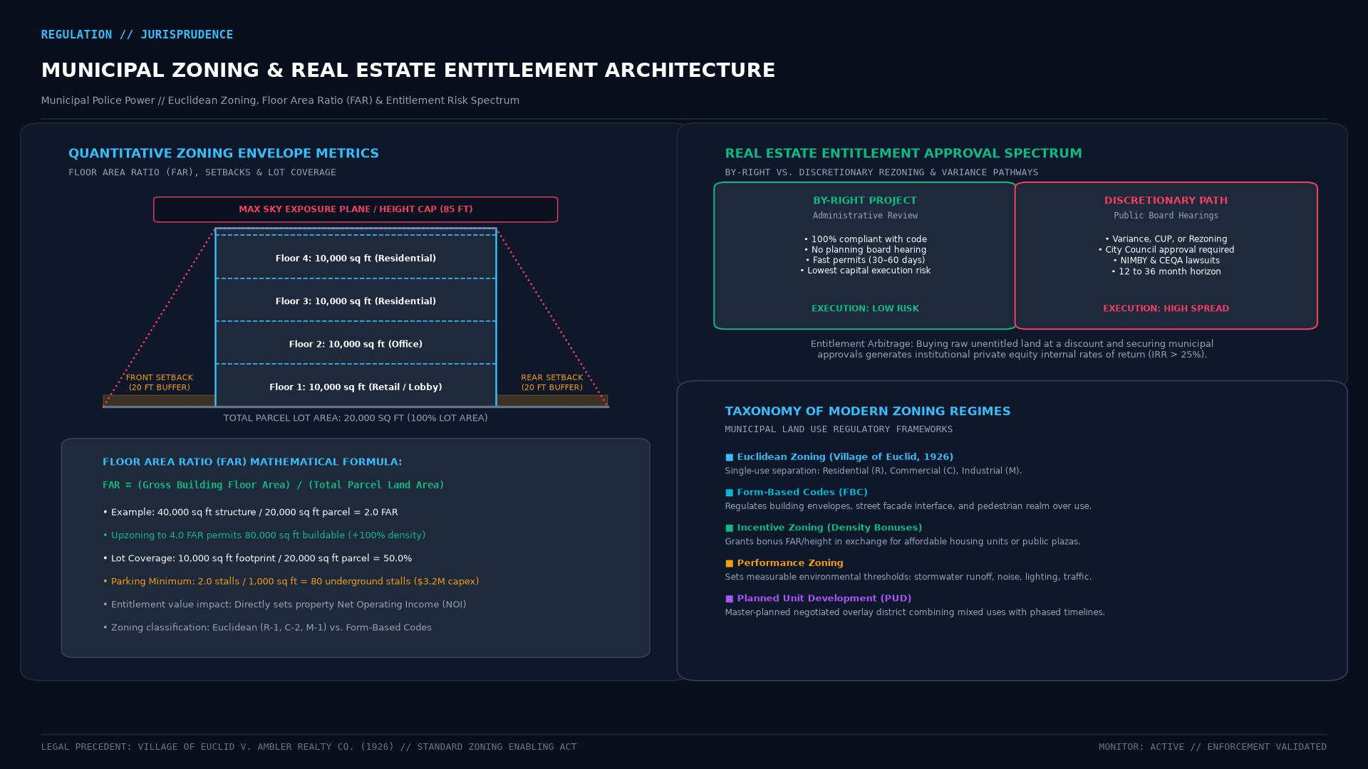 Figure: Municipal zoning envelope parameters (Floor Area Ratio, setbacks, lot coverage, and sky exposure plane) alongside the entitlement approval spectrum from by-right development to discretionary rezoning.
Legal Foundations and Historical Genesis
The constitutional validity of zoning regulations in the United States was established by the landmark Supreme Court decision in Village of Euclid v. Ambler Realty Co. (1926). The court affirmed that municipal governments possessed the legitimate constitutional authority under state police powers to restrict private property uses without paying compensation under the Fifth Amendment Takings Clause, provided the restrictions bore a rational relationship to the public welfare.
Following this decision, traditional single-use zoning became universally known as Euclidean zoning:
+--------------------------------------------------------------------------+
|                     Taxonomy of Modern Zoning Frameworks                 |
+--------------------------------------------------------------------------+
|  Zoning Regime        | Operational Focus & Structural Philosophy        |
+-----------------------+--------------------------------------------------+
|  Euclidean Zoning     | Strict spatial segregation of incompatible uses   |
|                       | (Residential, Commercial, Industrial, Agro)      |
|  Form-Based Codes     | Regulates physical building envelopes, street    |
|                       | facades, and public realm interface over uses    |
|  Performance Zoning   | Sets measurable environmental/impact thresholds  |
|                       | (noise, traffic volume, runoff, light pollution) |
|  Incentive Zoning     | Grants density/FAR bonuses in exchange for public|
|                       | amenities, such as affordable housing or plazas  |
|  Planned Unit         | Negotiated master-planned districts with custom  |
|  Developments (PUD)   | mixed-use standards and phased development rights|
+--------------------------------------------------------------------------+
Key Dimensional Metrics Regulated by Ordinances
Commercial real estate analysts evaluate several quantitative constraints within a zoning code to establish a site’s maximum buildable capacity:
+--------------------------------------------------------------------------+
|                  Quantitative Zoning Underwriting Metrics                |
+--------------------------------------------------------------------------+
|                                                                          |
|  [ Floor Area Ratio (FAR) ] = Gross Building Area / Total Lot Area       |
|  - A 2.0 FAR on a 20,000 sq ft lot permits 40,000 sq ft of building space|
|                                                                          |
|  [ Lot Coverage Ratio ]     = Building Footprint / Total Lot Area        |
|  - A 40% cap mandates that 60% of the parcel remain open ground/setbacks |
|                                                                          |
|  [ Setback Mandates ]       = Minimum distance from structure to lot line|
|  - Front, rear, and side yard buffers for emergency access and sunlight  |
|                                                                          |
|  [ Parking Minimums ]       = Prescribed parking stalls per 1,000 sq ft  |
|  - Dictates structured vs surface parking capital expenditures           |
|                                                                          |
+--------------------------------------------------------------------------+
1. Floor Area Ratio (FAR)
FAR is the primary determinant of development density. Calculated as the total gross floor area of the building divided by the surface area of the underlying land parcel:
$$\text{FAR} = \frac{\text{Gross Building Floor Area}}{\text{Gross Lot Surface Area}}$$
If a real estate developer purchases a 50,000-square-foot commercial parcel zoned for an FAR of 4.0, the developer can construct a building containing up to 200,000 square feet of interior space. If municipal planners upzone the district to an FAR of 6.0, the buildable area jumps to 300,000 square feet, increasing the underlying land’s development value without requiring the acquisition of additional land.
2. Setback and Height Plane Limitations
Setbacks mandate the open spatial buffer between a building’s exterior perimeter and property boundary lines. Additionally, urban ordinances frequently mandate sky exposure planes or setback step-backs at higher floors (a legacy of New York City’s 1916 Zoning Resolution) to ensure daylight reaches street-level pedestrian corridors.
3. Parking Minimums and Infrastructure Burdens
Historically, zoning codes required developers to provide arbitrary numbers of off-street parking spaces (e.g., 4.0 stalls per 1,000 square feet of retail, or 1.5 stalls per multi-family apartment unit). In high-density urban infill developments, structured underground parking can cost $40,000 to $70,000 per parking stall, rendering projects financially unviable. Modern urban zoning reforms increasingly eliminate or cap parking minimums to reduce construction costs.
Entitlement Risk and the Approval Process
In real estate development, a project’s regulatory path divides between administrative and discretionary approvals:
[ Developer Acquires Property / Option Agreement ]
                         │
                         ▼
[ Zoning Due Diligence: Code Audit & Title Examination ]
                         │
         ┌───────────────┴───────────────┐
         ▼                               ▼
  [ By-Right Project ]           [ Discretionary Approval Required ]
  - Complies with all codes      - Requires Variance, CUP, or Rezoning
  - Administrative review only   - Public Planning Board Hearings
  - Permits issued in weeks      - Political & Community Pushback (NIMBY)
  - Low execution spread         - 12 to 36 Month Entitlement Timeline
1. By-Right Development
A development is classified as by-right when the proposed architectural design, density, and intended commercial use comply with the existing zoning ordinance. In this scenario, municipal zoning officials cannot exercise subjective discretion to reject the project. The developer secures building permits through routine administrative reviews, minimizing carrying costs and interest rate exposure.
2. Discretionary Approvals: Variances and Conditional Use Permits
When a proposed development deviates from the strict letter of the zoning code, developers must seek discretionary relief through public hearings:
- Zoning Variance: Relief granted by a municipal Board of Zoning Appeals (BZA) to relax physical dimensional rules (such as setbacks or height limits). The applicant must legally prove unnecessary hardship arising from unique physical characteristics of the land parcel (such as severe topography or rock outcroppings). Personal financial hardship does not qualify for a variance.
- Conditional Use Permit (CUP) / Special Exception: Discretionary authorization for land uses that are fundamentally compatible with the zone but require specialized conditions to prevent community disruption (such as drive-through restaurants, gas stations, or rooftop entertainment venues).
- Comprehensive Rezoning: Petitioning the municipal city council to amend the zoning map to reclassify a parcel from low-density industrial (e.g., warehousing) to high-density mixed-use residential. This process requires extensive environmental impact studies, traffic mitigation plans, and political negotiations.
Legal Non-Conforming Uses: The “Grandfathering” Dilemma
When a municipality amends its zoning ordinance to reclassify a neighborhood, existing properties that operated legally under previous rules become legal non-conforming uses (commonly called “grandfathered” properties).
+--------------------------------------------------------------------------+
|                  The Legal Non-Conforming Operational Trap               |
+--------------------------------------------------------------------------+
|  Operational Status   | Current operation remains fully legal and valid. |
|  Expansion Limits     | Owner cannot expand footprint or increase scale. |
|  Abandonment Clocks   | Ceasing operations for 6 to 12 months forfeits   |
|                       | grandfathered rights permanently.                |
|  Destruction Rule     | If casualty (fire/flood) destroys >50% of the    |
|                       | building, reconstruction must comply with the    |
|                       | new, restrictive zoning ordinance.               |
+--------------------------------------------------------------------------+
For real estate underwriters, grandfathered status introduces severe tail risk. If a fire destroys 55% of an industrial warehouse situated in an area downzoned to single-family residential, local ordinances typically prohibit the owner from rebuilding the warehouse. The owner is forced to write down the asset value to residential land basis, creating massive credit losses for senior mortgage lenders unless specialized Law and Ordinance insurance coverage was secured.
Macroeconomic Debates: Exclusionary Zoning and Upzoning
In modern urban economics, zoning ordinances have become a central focus of macroeconomic policy debate:
| Economic Dimension | Exclusionary Euclidean Zoning | Pro-Density Upzoning (YIMBY Reform) |
|---|---|---|
| Housing Supply | Restricts supply; mandates large suburban single-family lots | Expands supply by permitting duplexes, triplexes, and ADUs |
| Median Home Prices | Escalates home prices via artificial land supply scarcity | Moderates housing inflation by increasing housing density |
| Labor Mobility | Prevents workers from relocating to high-productivity cities | Enhances regional economic output and labor efficiency |
| Municipal Infrastructure | Costly suburban sprawl; car-dependent utility networks | Efficient utilization of existing municipal transit and sewers |
Cities such as Minneapolis (via the Minneapolis 2040 plan) and states including California, Oregon, and Washington have enacted sweeping upzoning statutes. These legislative reforms eliminate exclusive single-family residential zoning statewide, allowing property owners to construct accessory dwelling units (ADUs), duplexes, and multi-family structures by-right, fundamentally reshaping residential real estate development.
Underwriting Due Diligence: Mitigating Zoning Risk
Institutional real estate investors execute a rigorous four-phase zoning audit prior to waiving acquisition contingencies:
[ Phase 1: Review Certified Planning & Zoning Map Classifications ]
                                │
                                ▼
[ Phase 2: Commission Comprehensive Zoning Due Diligence Report (PZR) ]
                                │
                                ▼
[ Phase 3: Audit Parking Counts, Setbacks, FAR & Historical Variances ]
                                │
                                ▼
[ Phase 4: Obtain Municipal Zoning Verification Letter (ZVL) ]
                                │
                                ▼
[ Phase 5: Secure ALTA 3.1 Zoning Title Insurance Endorsement ]- Planning and Zoning Reports (PZR): Institutional buyers commission third-party zoning analysis firms to review municipal code history, building department permits, and site surveys to certify full code compliance.
- Municipal Zoning Verification Letter (ZVL): Underwriters require a formal letter signed by the municipal zoning administrator confirming the property’s current zoning classification, active permitted uses, and the absence of outstanding zoning code enforcement violations.
- ALTA 3.1 Zoning Title Insurance Endorsement: Lenders protect their loan collateral by demanding an ALTA 3.1 zoning endorsement attached to the lender’s title insurance policy. This endorsement obligates the title underwriter to indemnify the lender against financial losses if an unrecorded zoning restriction invalidates the property’s legal use or mandates structural demolition.
Frequently Asked Questions
What is the difference between a building code and a zoning ordinance?
A zoning ordinance dictates what can be built on a property (use classification, building height, setbacks, and density). A building code (such as the International Building Code, or IBC) dictates how the structure must be constructed (fire-suppression systems, electrical wiring, structural load engineering, and plumbing safety).
Can a property owner sue a city for lost property value after a downzoning?
Generally, no. Under US legal precedent established in Euclid v. Ambler, a reduction in property value caused by municipal rezoning does not constitute a compensable “regulatory taking” under the Fifth Amendment, unless the reclassification deprives the owner of all economically beneficial use of the land (the legal standard established in Lucas v. South Carolina Coastal Council).
What is a by-right development?
A by-right development is a project that conforms to all existing dimensional, density, and land-use requirements outlined in the municipal zoning code. By-right projects require only administrative reviews and building inspections, exempting developers from public planning board hearings, community opposition, and political discretion.
Ready to trade forex?
Open a free demo account with a regulated broker. Practice with virtual funds before risking real money.